Started: jan 12, 2005
Last Update: may 8, 2005
The Map of the Canal du Midi
Introduction
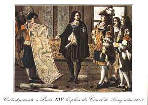
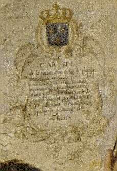 The right side of the painting is dominated by a group of men occupied with
hanging a large size map on the wall. This map represents the southern
part of France with the Mediterranean at the top. The key words in the
Joconde database and a letter in the Dossier at Versailles strongly suggest that
the map is linked with one of the major enterprises in 17th century
France: the construction of the Canal du Midi by Pierre-Paul Riquet.
The right side of the painting is dominated by a group of men occupied with
hanging a large size map on the wall. This map represents the southern
part of France with the Mediterranean at the top. The key words in the
Joconde database and a letter in the Dossier at Versailles strongly suggest that
the map is linked with one of the major enterprises in 17th century
France: the construction of the Canal du Midi by Pierre-Paul Riquet.
Baron Pierre-Paul Riquet de Bonrepos
 (b. 1604, Béziers, France--d. Oct. 1, 1680, Toulouse), French public
official and self-made engineer who constructed the epochal 150-mile
(240-kilometre) Canal du Midi (also called the Languedoc Canal) connecting
the Garonne River to the Aude River, thus linking the Atlantic and the
Mediterranean. The canal has been called the greatest civil engineering
project in Europe from Roman times to the 19th century.
(b. 1604, Béziers, France--d. Oct. 1, 1680, Toulouse), French public
official and self-made engineer who constructed the epochal 150-mile
(240-kilometre) Canal du Midi (also called the Languedoc Canal) connecting
the Garonne River to the Aude River, thus linking the Atlantic and the
Mediterranean. The canal has been called the greatest civil engineering
project in Europe from Roman times to the 19th century.
A tax collector under Louis XIV, Riquet interested himself in the
long-discussed problem of constructing a navigable waterway to provide a
shortcut from the Bay of Biscay to the Mediterranean. In 1662 he laid a
proposal before Jean-Baptiste Colbert, Louis XIV's finance minister.
Through Colbert's influence, Riquet obtained from the province of
Languedoc loans that permitted him to carry out the work, which required
many locks, a reservoir to provide water for the summit section during the
dry season, and the famous Malpas Tunnel, where Riquet became the first
engineer to use an explosive (black powder) for blasting rock. Worn out by
his labours, he died while executing the final work on the harbour of
Cette (modern Sčte) at the Mediterranean terminus. The canal opened the
following year (1681).Copyright 1994-1998 Encyclopaedia Britannica
Midi Canal
 also called LANGUEDOC CANAL, French CANAL DU MIDI, or CANAL DU LANGUEDOC,
major link in the inland waterway system from the Bay of Biscay to the
Mediterranean. A landmark engineering work carried out in France in the
17th century, the Midi Canal connects Toulouse with the Mediterranean and
provides a waterway to the Atlantic via the Aude and the Garonne. Rising
206 feet (63 m), via 26 locks, in its 32-mile (51.5-kilometre) journey to
the summit of its route, it runs 3 miles (5 km) along the summit, then
descends 114 miles (183.5 km) with a difference in elevation of 620 feet
(189 m) taken up by 74 locks. The engineer, Pierre-Paul Riquet, overcame a
rocky rise near Béziers by a daring innovation, employing black powder to
blast a 515-foot (157-metre) tunnel, 22 feet (6.7 m) wide and 27 feet (8
m) high, the first canal tunnel ever so built, and the first use of
explosives in underground construction. The canal was built between 1665
and 1681, with its final completion in 1692.Copyright 1994-1998 Encyclopaedia Britannica
also called LANGUEDOC CANAL, French CANAL DU MIDI, or CANAL DU LANGUEDOC,
major link in the inland waterway system from the Bay of Biscay to the
Mediterranean. A landmark engineering work carried out in France in the
17th century, the Midi Canal connects Toulouse with the Mediterranean and
provides a waterway to the Atlantic via the Aude and the Garonne. Rising
206 feet (63 m), via 26 locks, in its 32-mile (51.5-kilometre) journey to
the summit of its route, it runs 3 miles (5 km) along the summit, then
descends 114 miles (183.5 km) with a difference in elevation of 620 feet
(189 m) taken up by 74 locks. The engineer, Pierre-Paul Riquet, overcame a
rocky rise near Béziers by a daring innovation, employing black powder to
blast a 515-foot (157-metre) tunnel, 22 feet (6.7 m) wide and 27 feet (8
m) high, the first canal tunnel ever so built, and the first use of
explosives in underground construction. The canal was built between 1665
and 1681, with its final completion in 1692.Copyright 1994-1998 Encyclopaedia Britannica
More information can be found at http://www.canalmidi.com/. The pictures of Riquet and Colbert were found at this site.